Tropical Storm Idalia intensified overnight as it neared western Cuba and forecasters expect it to strengthen into “a dangerous major hurricane” by the time it reaches Florida’s Gulf Coast by early Wednesday. Florida Gov. Ron DeSantis said evacuation orders would likely be issued as the storm neared.
The storm is expected to strengthen slowly Monday as it moves into the Gulf of Mexico, but confidence is high among forecasters that rapid intensification will occur Tuesday, turning this storm into a Category 3 hurricane with winds of 115 mph or more.
“This is going to be a major hurricane,” said DeSantis, warning everyone in the storm’s path to make preparations and listen to local directives and evacuation orders.
“Floridians, you need to be executing your plans now,” he said Monday morning. “Late Tuesday, early Wednesday, it’s going to start to get really nasty.”
Idalia’s exact landfall location in Florida will be difficult to predict, since the storm is expected to parallel the state’s west coast. Life-threatening storm surge and dangerous winds were likely for the west coast of Florida and the Panhandle as early as late Tuesday.
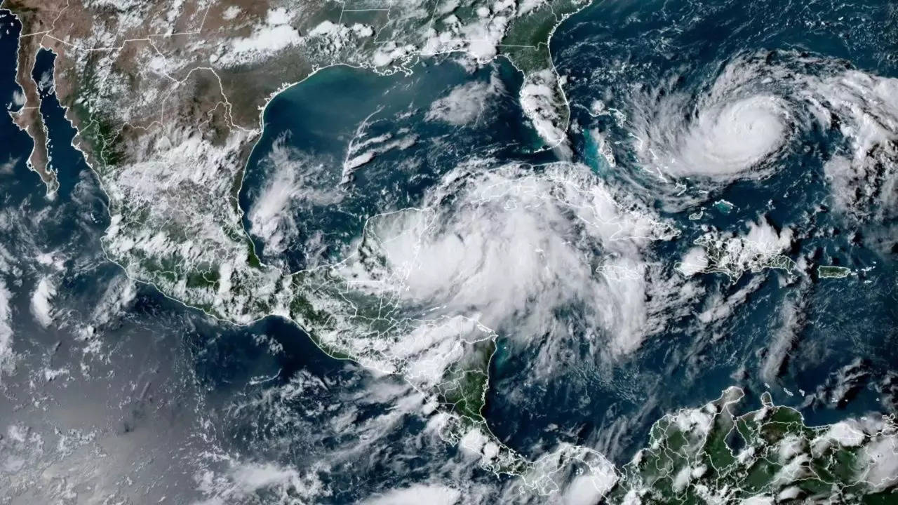
(Meanwhile, another storm, Hurricane Franklin, strengthened in the Atlantic, but was not expected to pose a serious threat to land.)
DeSantis said that evacuation orders would be issued along the Gulf Coast and for people to listen to their local officials. He also predicted school closures Tuesday, Wednesday and maybe Thursday.
The governor urged people to heed any warnings from local officials, including evacuation orders, but said that people didn’t need to go very far or even leave the state. “It’s not necessary to outrun the storm,” DeSantis said. “Just get to higher ground.”
“Evacuate tens of miles not hundreds of miles,” said Kevin Guthrie, the executive director of Florida’s Division of Emergency Management. He added that people in low-lying communities would need to evacuate because of the danger of a storm surge.
Storm surge watches were in effect for parts of Florida on Monday, as well as a hurricane watch extending from Englewood to Indian Pass, and including Tampa Bay. Hurricane watches were also in effect for Cuba. (A storm surge watch means there is a possibility of life- threatening inundation.)
A tropical storm watch was also issued from the Gulf Coast south of Englewood, which is about 80 miles south of Tampa, to Chokoloskee, a community roughly 65 miles south of Fort Myers, while a storm surge watch was in effect from Chokoloskee to Indian Pass.
Winds were predicted to reach a peak of 100 mph, Jamie Rhome, deputy director of the National Hurricane Center, said in an update Sunday evening.
“The hazards absolutely will extend beyond the cone,” he added, referring to the forecast maps showing the storm’s potential path. “Do not focus exclusively on the cone to determine your risk.”
“This is absolutely going to impact the state of Florida in many different ways,” DeSantis said, warning that people in the path of the storm would probably lose power, but that people outside of the cone could also experience severe impacts.
Idalia, pronounced ee-DAL-ya, also threatens to bring heavy rains to Georgia and the Carolinas, forecasters said.
The Florida Division of Emergency Management told residents to keep their gas tanks at least halfway full.
The state mobilized 1,100 members of the National Guard, which has 2,400 high-water vehicles and 12 aircraft ready for rescue efforts. Electric companies will have workers on standby starting Monday.
The Hurricane Center noted in an advisory Monday morning that Idalia could produce 4 to 7 inches of rain in western Cuba, and 4 to 8 inches in portions of the west coast of Florida, the Florida Panhandle, southeast Georgia and the eastern Carolinas.
On Sunday night, Cuba issued a hurricane warning for Pinar Del Rio, a city located a two-hour drive west of the country’s capital, Havana. The Cuban government also upgraded a tropical storm watch for the Isle of Youth to a tropical storm warning.
A tropical storm warning was issued for the Dry Tortugas islands, which had previously been under a watch advisory, and a watch was in effect for Lower Florida Keys West, west of the Seven Mile Bridge, the center said Sunday night.
The combination of the tide and storm surge was expected to bring water levels up to 11 feet in some parts of the Florida coast, forecasters said.
The west coast of Florida has been no stranger to hurricanes in the past several years.
Hurricane Ian in 2022 and Hurricane Michael in 2018 caused extensive damage from strong winds and storm surges after moving out of the Caribbean and rapidly intensifying in the Gulf of Mexico before striking Florida as major hurricanes.
Michael hit the Panhandle, while Ian hit the southwestern edge of the state.
The Atlantic hurricane season started June 1 and runs through Nov. 30.
In late May, the National Oceanic and Atmospheric Administration predicted that there would be 12 to 17 named storms this year, a “near-normal” amount. On Aug. 10, NOAA officials revised their estimate upward, to 14 to 21 storms.
There were 14 named storms last year, after two extremely busy Atlantic hurricane seasons in which forecasters ran out of names and had to resort to backup lists. (A record 30 named storms took place in 2020.)
There is consensus among scientists that hurricanes are becoming more powerful because of climate change. Although there might not be more named storms overall, the likelihood of major hurricanes is increasing.
Climate change is also affecting the amount of rain that storms can produce. In a warming world, the air can hold more moisture, which means a named storm can hold and produce more rainfall, like Hurricane Harvey did in Texas in 2017, when some areas received more than 40 inches of rain in less than 48 hours.
The storm is expected to strengthen slowly Monday as it moves into the Gulf of Mexico, but confidence is high among forecasters that rapid intensification will occur Tuesday, turning this storm into a Category 3 hurricane with winds of 115 mph or more.
“This is going to be a major hurricane,” said DeSantis, warning everyone in the storm’s path to make preparations and listen to local directives and evacuation orders.
“Floridians, you need to be executing your plans now,” he said Monday morning. “Late Tuesday, early Wednesday, it’s going to start to get really nasty.”
Idalia’s exact landfall location in Florida will be difficult to predict, since the storm is expected to parallel the state’s west coast. Life-threatening storm surge and dangerous winds were likely for the west coast of Florida and the Panhandle as early as late Tuesday.
(Meanwhile, another storm, Hurricane Franklin, strengthened in the Atlantic, but was not expected to pose a serious threat to land.)
DeSantis said that evacuation orders would be issued along the Gulf Coast and for people to listen to their local officials. He also predicted school closures Tuesday, Wednesday and maybe Thursday.
The governor urged people to heed any warnings from local officials, including evacuation orders, but said that people didn’t need to go very far or even leave the state. “It’s not necessary to outrun the storm,” DeSantis said. “Just get to higher ground.”
“Evacuate tens of miles not hundreds of miles,” said Kevin Guthrie, the executive director of Florida’s Division of Emergency Management. He added that people in low-lying communities would need to evacuate because of the danger of a storm surge.
Storm surge watches were in effect for parts of Florida on Monday, as well as a hurricane watch extending from Englewood to Indian Pass, and including Tampa Bay. Hurricane watches were also in effect for Cuba. (A storm surge watch means there is a possibility of life- threatening inundation.)
A tropical storm watch was also issued from the Gulf Coast south of Englewood, which is about 80 miles south of Tampa, to Chokoloskee, a community roughly 65 miles south of Fort Myers, while a storm surge watch was in effect from Chokoloskee to Indian Pass.
Winds were predicted to reach a peak of 100 mph, Jamie Rhome, deputy director of the National Hurricane Center, said in an update Sunday evening.
“The hazards absolutely will extend beyond the cone,” he added, referring to the forecast maps showing the storm’s potential path. “Do not focus exclusively on the cone to determine your risk.”
“This is absolutely going to impact the state of Florida in many different ways,” DeSantis said, warning that people in the path of the storm would probably lose power, but that people outside of the cone could also experience severe impacts.
Idalia, pronounced ee-DAL-ya, also threatens to bring heavy rains to Georgia and the Carolinas, forecasters said.
The Florida Division of Emergency Management told residents to keep their gas tanks at least halfway full.
The state mobilized 1,100 members of the National Guard, which has 2,400 high-water vehicles and 12 aircraft ready for rescue efforts. Electric companies will have workers on standby starting Monday.
The Hurricane Center noted in an advisory Monday morning that Idalia could produce 4 to 7 inches of rain in western Cuba, and 4 to 8 inches in portions of the west coast of Florida, the Florida Panhandle, southeast Georgia and the eastern Carolinas.
On Sunday night, Cuba issued a hurricane warning for Pinar Del Rio, a city located a two-hour drive west of the country’s capital, Havana. The Cuban government also upgraded a tropical storm watch for the Isle of Youth to a tropical storm warning.
A tropical storm warning was issued for the Dry Tortugas islands, which had previously been under a watch advisory, and a watch was in effect for Lower Florida Keys West, west of the Seven Mile Bridge, the center said Sunday night.
The combination of the tide and storm surge was expected to bring water levels up to 11 feet in some parts of the Florida coast, forecasters said.
The west coast of Florida has been no stranger to hurricanes in the past several years.
Hurricane Ian in 2022 and Hurricane Michael in 2018 caused extensive damage from strong winds and storm surges after moving out of the Caribbean and rapidly intensifying in the Gulf of Mexico before striking Florida as major hurricanes.
Michael hit the Panhandle, while Ian hit the southwestern edge of the state.
The Atlantic hurricane season started June 1 and runs through Nov. 30.
In late May, the National Oceanic and Atmospheric Administration predicted that there would be 12 to 17 named storms this year, a “near-normal” amount. On Aug. 10, NOAA officials revised their estimate upward, to 14 to 21 storms.
There were 14 named storms last year, after two extremely busy Atlantic hurricane seasons in which forecasters ran out of names and had to resort to backup lists. (A record 30 named storms took place in 2020.)
There is consensus among scientists that hurricanes are becoming more powerful because of climate change. Although there might not be more named storms overall, the likelihood of major hurricanes is increasing.
Climate change is also affecting the amount of rain that storms can produce. In a warming world, the air can hold more moisture, which means a named storm can hold and produce more rainfall, like Hurricane Harvey did in Texas in 2017, when some areas received more than 40 inches of rain in less than 48 hours.
Denial of responsibility! Yours Headline is an automatic aggregator of the all world’s media. In each content, the hyperlink to the primary source is specified. All trademarks belong to their rightful owners, all materials to their authors. If you are the owner of the content and do not want us to publish your materials, please contact us by email – [email protected]. The content will be deleted within 24 hours.